

A Bancroft History
Compiled by Neal Baxter
In October 2013, Catherine Mandle of the Bancroft board asked me if I’d like to present a talk about the history of our neighborhood. I said I would, and we set a tentative date for the end of January. I soon expanded the area I wanted to talk about to include 34th-42nd Streets, and 3rd Avenue to Cedar. This would draw in all the local schools and parks.
Bancroft is a small neighborhood exactly in the middle of south Minneapolis. From the 4 edges of the neighborhood (38th, 42nd, Chicago and Cedar) the lakes are 2 miles west and the river is 2 miles to the east. Likewise, City Hall and Richfield are both 2 miles distant. Uptown and the West Bank campus of the University are both 3 miles off. Because Bancroft enjoys a situation central to many of the places I want to go, I have a delightful walk to almost any destination I choose.
Bancroft and its vicinity has 12 schools or former school properties, 12 parks or green open spaces, and 12 churches. I’ll try to have a story about each one.
POLITICS
Bancroft comprises the northeastern 3/8ths (240 acres) of Section 11, Township 28, Range 24 West of
Hennepin County. Our neighborhood was part of Richfield until March 7, 1867, when the Legislature
transferred the area between Lake Street (as it is now) and Brown’s Creek (now Minnehaha) to
Minneapolis Township. From 1883, when Powderhorn was added to the City, to 1887, 38th Street was
the southern boundary of the city. Minneapolis Township ceased to exist in 1887, when it was annexed
to the City of Minneapolis.
Bancroft has undergone many changes in political orientation in its history, Before the City of Minneapolis took control, Bancroft was part of:
France’s American empire 1680-1763
Spain’s American empire 1763-1803
the District of Louisiana 1804-1805
Louisiana Territory 1805-1812
Missouri Territory 1812-1821
Fort Snelling Reservation 1820-1849
Michigan Territory 1834-1836
Wisconsin Territory 1836-1838
Iowa Territory 1838-1846
Minnesota Territory 1849-1858
Richfield Township 1858-1867
Minneapolis Township 1867-1887
Bancroft was in Ward 11 from 1887 to 1891, Ward 7 from 1891 to 1947, Ward 11 again from 1947 to 1961, and has been in Ward 8 since 1961. Our neighborhood was part of Park District #33 from 1917 to 1963, #35 from 1963 to 1969, and #5 since 1969.
A number of public officials have lived in Bancroft:
William B. Woodward, 12th Ward Alderman 1889 to 1893, then 7th Ward Alderman from 1891 to 1895, lived at 3812 10th Avenue.
H.L. Moore, 7th Ward Alderman 1913 to 1915, lived at 3824 10th Avenue, then moved to 3820 by 1915.
John Swanson, 7th Ward Alderman 1927 to 1939, lived at 3852 Bloomington.
Elwood B. Swanson, owner of Swanson Grocery at 2404 E. 25th Street, was 7th Ward Alderman from 1945 to 1947. He continued as Bancroft’s alderman until 1953, as 11th Ward Alderman. He lived at 4012 Elliott.
Pam Costain, School Board member 2007-2011, lives at 3952 12th Avenue.
Only one of Bancroft’s politician-neighbors has ever been indicted for a crime. Here’s his story:
William B. Woodward, 7th Ward Alderman
Woodward enjoyed relaxed ethical standards. Among his misdeeds, let two suffice. On Oct. 31, 1896, Woodward bribed a church officer. He proposed to the treasurer of Oliver Presbyterian Church, at 27th & Bloomington, that a city assessment against church property could be annulled if Woody were re-elected. In conversation he produced a check to help the church meet its other obligations. When a church member heard of this transaction, he told the church leaders, and the Trustees ordered the Treasurer to return the check to Woodward.
His last crooked deed while alderman? His shady pals on the Council appointed Woodward treasurer of their group. They arranged that candidates for alderman should agree to join the “combine” after election, or be told they’d never get the nomination. The “combine” brought in $3500, and after the election, Woodward ran off with the kitty. He was reported to be out East, shopping for carriages with which to open a carriage dealership. On Jan. 30, 1897, the papers reported that Woodward was in Veracruz, in Mexico, relaxing at the coffee plantation of ex-Alderman George Flanders.
RESIDENTS OF BANCROFT
For me, the most interesting thing about any place is the people who lived there. The first people to live in or near Bancroft were, of course, the Dakota.
The Dakota didn’t live in Bancroft, as far as I know, but they did farm wild rice out of Lake Hiawatha (which was called Rice Lake until Nov. 4, 1925).
Lake Nokomis, by the way, was first called Lake Amelia, after the daughter of Captain George Goodings. The name was changed on Dec. 5, 1910. John C. Calhoun, eminent politician from South Carolina, gave his name to the lake west of here, as he was Secretary of War at the time Fort Snelling was established. Col. Snelling didn’t name the fort after himself; the War Department wanted to recognize him, and gave the fort Snelling’s name in 1825.
So, the Dakota were here first, last and always. The Ojibwe began moving into Minnesota around 1700, from east of Lake Superior. The Anishinabe and the Dakota fought for 150 years (from 1736-1858) over Minnesota. In fact, they fought a battle in the streets of St. Paul, in 1853! The last battle in the fight for the Minnesota country took place outside of Shakopee, in 1858.
No whites seem to have settled in Bancroft until the 1870s, at least, though someone always owned the land. One indication of sparse settlement around this area is the lack of public transit south of 34th Street until the 1880s.
Fort Snelling was established in 1819 in order to finally make good the US claim to the Upper Mississippi Valley. Before Minnesota territory was set up in 1849, one of the duties of the Fort Snelling detachment was to keep whites out of Minnesota west of the Mississippi. Only whites with provable missionary credentials or trappers with one of the fur companies were allowed to cross the Mississippi River. All others were escorted by soldiers to the east bank, and off the Reservation. That’s how St. Paul was first settled, in fact, by squatters on the Fort’s property (“the Reserve”). Henry Sibley was local head of the American Fur Company, and was based in Mendota from 1834. The Pond brothers lived with the Dakota and were sent to the Minnesota country as missionaries. Not a lot of other white folks had any business in Bancroft at that time.
BANCROFT'S FIRST LANDOWNER
Franklin Steele was the fort storekeeper. Steele made a lot of money from the soldiers at the Fort, and was in a position to buy valuable land as soon as the Minnesota country opened up west of the Mississippi River. He bought all the land opposite St. Anthony Falls, what’s now downtown Minneapolis, in March 1849.
In 1858 the US government decided the state government could manage the country’s interests in this vicinity, and sold the fort and much of the surrounding land to Steele for $90,000. When the Civil War broke out, Steele promptly leased the fort back to the US, for $2000 per month! He made a killing.
Below is a small part of a map of Minneapolis and vicinity published in 1879. The “11” identifies the area immediately as Section 11. The road just left of the “E” in “Elisha” is now Chicago Avenue; his land is bounded by Chicago, 38th St, Bloomington Avenue and 44th Street. Notice the lake astride Bloomington Avenue, about where El Colegio is now. And the other, just north of present day Sibley Park. They were filled in, built on and only in the 1980s was the drainage problem recognized in these areas.
The 3 blocks where flooding of houses grew into a big problem were cleared starting in the late 1980s. The houses where The Bancroft Meadows is now came down in 1988 or 1989. The 3800 block of 19th Avenue was cleared of houses in 1988 or 1989 after a resident was killed when his flooded basement wall collapsed on him. The block was made into a kind of addendum to Sibley Field.
The houses on Park and Columbus Avenues at 37th Street were destroyed after 2000, and made a park.
Below you’ll see a map of the Bancroft from the 1903 atlas of Minneapolis. Portland Avenue runs along the left edge of the page, so Chicago Avenue is easy to find. The 8 blocks south of 38th Street and east of Chicago were platted as Chicago Avenue Park, and the first houses in Bancroft were all built here. At least half a dozen 19th Century homes survive in the area.

Map showing Bancroft neighborhood, 1903
Bancroft's HISTORICAL POPULATION
Bancroft attracted a diverse population from an early day, but the makeup of that diversity has changed over time.
In 1900, the 19 men and women who were heads of households included 12 native-born Americans and 7 immigrants:
4 Canadians
2 Germans
1 Englishman
4 from Maine
2 from Massachusetts
2 from Wisconsin
2 from Ohio
1 from New York
1 from Indiana
Ninety-four men, women and children lived in Bancroft in April 1900. They came from:
5 Canada
3 Germany
2 Sweden
1 England
1 Scotland
43 were born in Minnesota
10 Maine
5 Ohio
4 New York
3 from Indiana
3 Massachusetts
3 Pennsylvania
3 Wisconsin
2 West Virginia
2 Vermont
1 Illinois
1 Michigan
(2 I forgot to write down)
Among the 185 heads of households listed in the 1910 U.S. Census (compared with the roughly 1000 households today), 110 were Americans by birth, 47 of these born in Minnesota. Of the foreign-born, 36 came from Sweden, 19 form Norway, 7 from Canada, 4 each from Denmark and Great Britain, 3 from Germany and 2 from Ireland. The 165 wives amongst the households in Bancroft included 52 women born in Minnesota, and 54 born in other states. Those born abroad included 29 Swedes, 18 Norwegians, 4 Canadians, 4 Germans, 2 Danes, 1 Englishwoman and 1 Irish immigrant.
Of the 216 husbands and wives and single parents born in the U.S.A. and living in Bancroft in 1910, 24 had a Swedish father, 22 had a Norse father, 14 a German father, 15 had a British father, 11 had an Irish father, 5 had Canadian fathers, 2 French and 2 Danes.
Black Families Living Near Bancroft
From the 1910 U.S. Census:
3603 Chicago Eliza Johnson & family
3613 Chicago Simon Gould & Family
3710 Chicago Harrison & John Smith
3637 10th Ave. S. Charles Butler
3836 11th Ave. S. Silvester De Lucker
3840 11th Ave. S. Bert Young, Matthew Ornsby & Joseph Bennie
3908 Bloomington Earle M. Jones & family
3707 18th Ave. S. Thomas Williams
3709 18th Ave. S. George W. Lillard
3717 18th Ave. S. Andrew Lawrence & family
3725 18th Ave. S. George W. Butler & family
3745 18th Ave. S. Aaron Stitt & family
3753 18th Ave. S. Abraham Walton
3823 Cedar Ave S. Mr. Roberts
3345 20th Ave. S. John Simson & Sarah Were
3021 21st Ave. S. Pleasant Gibbs
3420 21st Ave. S. Vallermine Smith & family
Thomas Williams
Eugene Coats
As an appendix, I’ll put at the end of this narrative all the earliest residents of Bancroft, and who lived in the oldest houses until 1920. For now, I’ll just mention that the oldest house according to the Hennepin County Property Tax website is 3915 Elliot. The house dates from 1895, and is the only house built before 1900, according to Hennepin County. I believe otherwise, and the list at the end will demonstrate what I mean. So, always keep an open mind about your sources, even your best sources!
Schools
Once you know people were living here, you have to ask where their children went to school. Until 1911, the year Bancroft school opened its doors, most of the local children attended Horace Mann school, at Chicago & 34th Street. In the 1888/1889 school year, the Horace Mann school district included everyone living west of 14th Avenue from Lake Street to 34th Street, and west of Bloomington Avenue from 34th Street to 54th Street. Children living north and east of 37th & Bloomington attended Corcoran school. Horace Mann held pupils through 8th grade in those days. From 9th grade, children went to high school. The closest high school until South High (24th & Cedar) was built in 1894 was Central High (4th Avenue & 12th Street).
Children living north and east of 37th Street & Bloomington (as far as 22nd Avenue) went to Corcoran,
The other nearby school choices for children were:
Bryant (38th & 4th Ave.) grades 1-3
Minnehaha (42nd & M’haha) grades 1-4
Bancroft (38th & M’haha) grades 1-3
After Miles Standish school was built in 1920, children living east of the 17th-18th Avenue alley from 37th to 42nd went to classes there; all other Bancroft children lived in the George Bancroft district. At the same time, 13th Avenue divided Bancroft neighborhood between Central and South High students.
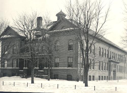
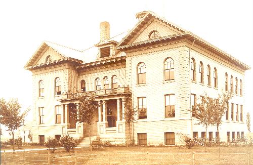
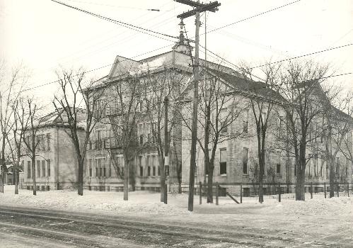
Bancroft School, 3800 Minnehaha Avenue
In 1875 Minneapolis Township built a wooden, two-room school, District #113, on the southwest corner of Minnehaha Avenue and 38th Street. The school became part of the city school system when the neighborhood was annexed in May 1887, and received the name “Bancroft” later in the year. Bancroft served 21 to 29 children from 1887 to 1890. Closed in 1890, this building was moved in 1894 to the grounds of Monroe School for use as an annex. The building now located at 38th & Minnehaha was Simmons School until 1940.
The current Bancroft School, 1315 East 38th Street, was built in 1911 on land purchased in 1910. The school opened on Oct. 30, 1911, with no name, in a 4-room shack. In 1912 the school was named after American historian George Bancroft, born 1800. An addition was built in 1920.
From the 1912/1914 Mpls School Board Report on Bancroft School population:
| 1911/1912 | 1912/1913 | 1913/1914 |
|---|---|---|
| 3 Teachers | 15 Teachers | 20 Teachers |
| 22 Pupils | 341 Pupils | 827 Pupils |
Simmons School, 3800 Minnehaha Avenue
Built in 1905 on the site of old Bancroft school, with additions that were built in 1907, 1911 and 1914. The school opened in January 1906 and closed in 1942. Named for Henry M. Simmons, a local Unitarian minister (born 1841). This building now serves as an apartment house.
Bryant School was built by Minneapolis Township in 1885
The township placed two wooden buildings at 4th & 38th Street (where Kente Circle is now, on the southwest corner). The 3-room schoolhouse, District #117, was named after William Cullen Bryant (1794-1878), an American poet who was also editor of the New York Evening Post.
In 1898, a new Bryant school replaced this one, at 3707 3rd Avenue South. In 1927, Bryant was renamed for Alice Warrington, (born 1863), principal of Bryant School from 1885 to 1925. Warrington Elementary School closed in 1966.
A second District #117 property, at Park & 38th Street, was purchased in October, 1876. The school building sat on the north side of 38th Street, at the Columbus Avenue end of the lot. Sometime before 1889 the Minneapolis School administration moved the building off the lot. The 1885 Atlas of Minneapolis shows the “School District” between Park & Columbus. The school is never included in the lists of Minneapolis schools, and may have been still on site when Mann school was built in 1886. Apparently the School Board, when the City limits were extended from 24th Street out to 38th Street, decided not to use the Township’s #117 school
Mann School, 3345 Chicago Avenue
Built in 1886, with additions built in 1905, 1916 and 1966. Mann was closed from 1942 to 1945, and closed permanently in 1974. The old schoolhouse was torn down and Wilder School built on the site. Named for Horace Mann, American educational reformer, born 1796.
Mann served grades 1-8 from 1889/1890 until past 1892/1893, as the City had no junior high schools.
Wilder School, 3345 Chicago Avenue, was built in 1974-1975 on the site of Mann School. The school opened in 1975, and was named for Laura Ingalls Wilder, author, born 1867. Wilder had 3 schools in 1:
Wilder A, a K-6 (3322 Elliot Avenue);
Wilder B, ungraded, (3328 Elliot Avenue); and
Wilder C, ungraded, (3320 Elliot Avenue)
Powderhorn, 3328 Elliot
In 1997 Wilder K-6 was re-named Powderhorn Community School.
Corcoran School, 3329 19th Avenue South
Wooden annexes from Garfield and Irving schools served as classrooms while Corcoran was under construction, in 1888-1889. The school closed in 1975. At the urging of neighbors a park was built on the site. Named for William Wilson Corcoran (born 1789), a merchant who founded the Corcoran Gallery in Washington, D.C.
Central High School, 3416 4th Avenue South
The original Central High School was built in 1877-1878, at 4th Avenue and 12th Street. It served as the only city high school for years. Old Central closed in 1913, when the new Central High opened on 34th Street. However, during its first year of retirement, the old high school housed the pupils of North High while the new North was under construction; Girls Vocational High; and William Hood Dunwoody Institute (which later moved to its present site on Wayzata Boulevard). Later, this site became home to the city’s Vocational school.
The second Central High, at 3416 4th Avenue South, was built and opened in 1913. An addition was completed in 1922. The school closed in 1982, and was demolished. Richard Green School occupies the site now. Townhouses now occupy what was the Central High football field across 35th Street.
Green Central Park School, 3416 4th Avenue South
Green opened in 1993 on the site of Central High School. The school is named for Dr. Richard Green, Superintendent of Minneapolis Schools from 1980 to 1988. Green was the first black superintendent in Minneapolis. He moved to New York City to head the New York schools, and died in 1989.
Standish School, 2200 East 40th Street
A portable opened on this corner in 1916. The brick schoolhouse was built in 1920-1921 (addition 1923), and closed in 1982. Named for Miles Standish, Massachusetts pioneer (born 1584?) and hero of a poem by Longfellow. A housing development now occupies this site.
By the way, the oldest extant school buildings in Minneapolis are:
Kenwood Adams Pratt Fuller
Whittier Bancroft Simmons
Holy Name School, Catholic, opened at 37th & 11th Avenue in 1933.
El Colegio, 42nd & Bloomington
El Colegio opened its doors in September 2000. It is a small public high school, with classes in English and Spanish. It occupies the site and the building of a Country Club Market grocery store. Many Bancroft residents remember that supermarket.
Area Parks
Powderhorn Park
15th Avenue South and East 34th Street, just under 66 acres, of which the lake covers 11½ acres.
The park is named after its lake, which has the shape of the horn used to carry gunpowder for old rifles. The name attached to the lake from at least 1839, when a report on the Fort Snelling Reservation mentioned the lake by that name. The name was never formally adopted by the Board.
Residents near Powderhorn Lake first asked the Park Board to create a park here in 1883. The newly-created Park Board had other priorities. One of them was a plan to develop Lake Street as a parkway from the Mississippi River to Lake Calhoun. When property adjoining Lake Street proved too expensive, 34th Street began to look like an alternative. The 34th Street parkway would link with St. Paul’s Summit Avenue (already under development by Horace Cleveland) and also feature Powderhorn Lake. Horace Cleveland, the Park Board landscape architect, developed Summit Avenue per plan, but Minneapolis never developed 34th Street as a parkway, as costs here also proved too high.
The Board finally bought 38 acres near Powderhorn Lake in 1890, and added 45 acres by the end of 1891. The winter of 1891/1892, the Park Board opened one of the first skating rinks in Minneapolis here. The park hosted speed skating championships throughout the 1930s. An estimated 50,000 attended in 1934. Olympic trials in 1935 suffered from bitter cold weather, but at the 1947 Olympic speed skating trials four of the winning skaters lived in the Powderhorn neighborhood, and one of them took third place in the 1948 Olympics.
Phelps Field Park
The Park Board bought the 8-acre property at Chicago & 39th Street in 1917, and developed it in 1922. Originally called Chicago Avenue Field, the park was named for Edmund J. Phelps in 1939. Phelps served on the Park Board from 1905 to his death in 1923, and was president in 1912 and 1913.
A renovation of Phelps Park in 1993 & 1994 added a gym. Contributions came in from the McKnight and Minneapolis Foundations, the local neighborhood associations and the Boys and Girls Club. In exchange for helping upgrade the park, the Boys and Girls Club has operated programs in the park building ever since.
Sibley Field Park
Sibley Park occupies nearly 8 acres north of Longfellow Avenue & 40th Street. The topography of these 2 blocks was most irregular, and 68,000 cubic yards of dirt were moved to level out the ground for the park.
The land was purchased in 1922, and was developed at the same time as Phelps Park, a mile west. The park’s original name, Cedar Heights Park, was changed on January 17, 1923, to honor Henry Sibley, Minnesota’s first governor.
Between 1987 and 1990, the block across 39th Street was leveled and all the houses removed.
Corcoran Park, at 34th & 19th Avenue, was the site of Corcoran School until 1975. When the School Board tore down the old school, neighbors expressed an interest in having a park there.
Area Churches
In 1900, Nazareth English Lutheran Church opened its doors at 3952 Elliott. They must have built the church, as they were a new congregation, unknown in 1899. In 1923, Calvary Lutheran was founded and services began on 39th Street and Chicago. The present edifice was built in 1930.
In 1915 or 1916, Open Door Congregational Church began worship services at 3900 Elliott. The congregation moved from their previous location on Jefferson and NE 13th Avenue.
In 1955, Bethel Lutheran parishioners moved from their old church at 3152 17th Avenue South to the present building, built on vacant land at 41st & 17th Avenue.
The former funeral chapel on 3644 Chicago was turned into a Bahai chapel in 2000 or 2001. Bahai was founded by a Shiite Moslem fellow in the 19th Century. The building dates from 1927, and was home to Barney Anderson & Son undertakers for over 40 years. McDivitt Funeral Chapel owned the building from 1969 to 1984 or so. The Boys & Girls Club replaced the funeral directors between 1985-1993.
Holy Name church dates from 1917; the school on 37th Street opened in 1933.
The Grace & Truth Gospel Hall moved to 14th Avenue and 37th Street (from 2941 5th Avenue South) in 1926/1927.
Before the new Seward Coop opened in 2015, and before Greater Friendship Missionary Baptist Church moved from 3805 3rd Avenue to 2600 38th Street, the Church of God in Christ held services on the site. The Outreach for Christ church has stood at 38th & Chicago since the mid-1980s.
I should mention here that the area’s two cemeteries date from the 1870s. Montefiore has been on 42nd Street since 1878, and the Catholic cemetery and the orphanage both date from the early 1870s. According to the 1885/1886 city directory, these graveyards are located on the “Richfield road,” way out of town, and on the main drag leading to Richfield Mill, at Lyndale Avenue and Minnehaha Creek. Richfield Road is 3rd Avenue South today.
Commercial
Rebecca Rand, notorious madame and entrepreneuse, owned the Relax-a-Lounge bath house, massage parlor and escort service around 1990. The pleasure never stopped at 1824 East 38th Street. That’s on the corner of 38th & Cedar, next door to the amazing record shop with 78 RPMs for sale.
Our very own shopping mall got its start in the late 1950s, when National Foods built a grocery store on vacant land at 40th & Bloomington.
Around 1900, small local dairies supplied many city people with their dairy products. Dairies around Bancroft included Iver O. Weikle’s dairy, at 4110 18th Avenue South (1913), and J.A. Wile Dairy at 4010 Chicago (1900), and Freden & Oden’s. August Freden and John F. Oden moved their dairy from 3639 19th Avenue South to 3841 Bloomington in 1903. Freden and his family lived by the dairy; the Odens lived at 3829 Bloomington. They carried on their business until after 1910. By 1913 the number of dairies in Minneapolis dropped sharply. Oden left the business, and Freden carried on without him for a few years. In 1920, August Freden was still living on Bloomington Avenue, and Oden’s widow, Dorothy, still lived in the house at 3829 Bloomington (see more in the appendix).
Fire Stations
The original fire stations were far away for many years. Station N, the closest one, was on 17th Avenue South, between 25th & 26th Streets. In 1890, Station Q was built at Chicago & 35th Street, on the NW corner (re-named Station 17 in 1910). The fire station at 35th & Elliot replaced this one in 1941. The newest Station 17 was built at 4th Avenue & 38th Street in 1992.
Fire alarms were set up at Chicago & 34th and Chicago & 38th in 1892. In 1910 fire alarm boxes were added at 10th Avenue & 39th Street, 11th Avenue & 36th Street and Portland & 37th Street.
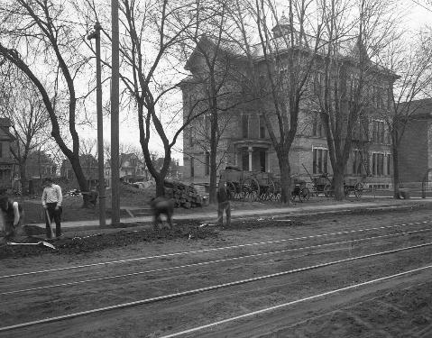
Area Transit
In the 1880s, 4th Avenue, Chicago, Bloomington and Cedar all had horse-drawns, none of which journeyed south of 35th Street. The first horse-drawn transit line in our area carried passengers between downtown and 34th Street on 4th Avenue, starting in 1876. The line was converted to trolley in 1888 and extended to 38th St in 1890.
The Chicago Avenue trolley first ran in 1890, from downtown to 35th Street. The line was extended to 46th St in 1904.
The Bloomington Avenue line was extended from 32nd to 38th in 1911, and to 48th Street in 1922. A trolley operated on Cedar Avenue as far as 35th Street by 1891. The service was extended to 42nd Street in 1914.
In the 1890s, a bus line, the Minnehaha Branch Motor Line, ran along 37th Street from Nicollet to Fort Avenue (Minnehaha), and on Fort Avenue to Minnehaha Falls. The 38th Street bus started operating in 1926, between Colfax and 34th Avenue. Service was extended to 42nd Ave in 1929. In 2005 the route was extended to Uptown and to Highland Park in St. Paul.
Libraries
The nearest public library branches in 1893 were Franklin Ave (Franklin & Bloomington) and one at 3103 Nicollet. James K. Hosmer was the Head Librarian at the time.
Library book delivery stations were set up at 3803 4th Avenue and at 35th & Chicago in 1909. The address on Chicago changed to 3457 Chicago in 1912, and to 3500 Chicago in 1915. When the 36th Street Branch Library opened in January 1916 (at 36th & 4th Avenue), the delivery stations in our neighborhood closed. The library was re-named Hosmer in 1926, to honor James K. Hosmer, the library system’s 2nd head librarian.
Library Rules in 1912: open 8:30-10 PM, 2-10 PM on Sunday (reading rooms and reference only) books checked out for 14 days and renewable; recently acquired books could only be checked out for 7 days, non-renewable; limit: 2 fiction books and no limit for non-fiction; fines: 2 cents per day.
An average of 3,000 books were lent per day that year, to 6,500 card-carrying subscribers.
A Word about Sources for Finding Out about your House
Minneapolis is blessed with several excellent storehouses of useful local historical information. The Central Library downtown has almost anything about local government, schools and populations you would want to learn. All the city directories are available, and from 1930 the directories included street inventories as well as everyone’s address in alphabetical order. So you can look up who lived on your whole block, through time.
Also downtown are the city atlases, which show buildings and give the legal description of every lot in the city. Atlases for the years 1887, 1891, 1903, 1914 and 1940 are most helpful for houses in Bancroft.
The Hennepin History Museum has a splendid collection in a very small space at 2303 Third Avenue South. The Museum has the original color editions of the city atlases, plus the city directories, Sanford insurance maps, and more. It’s a delightful place to visit, too.
The Property division of Hennepin County, on the 5th floor of the Court House, has the legal records for every property in the County. The records go back to the mid-19th century, and tell you who owned the land your house sits on.
If you want to know who lived in your house before you moved in, the US Census can tell you. The downtown library has most of the census records for Minneapolis; the University of Minnesota library on the West Bank has all the US census material. The University also has all the Minnesota censuses, which were taken in 1857, 1865, 1875, 1885, 1895, and 1905. The last two give addresses, while the first give no idea where the respondents lived.
Your on-line resources include the Hennepin County library, which so far has digitized the city directories up to 1922, and can take you to the US Census returns (via HeritageQuest). Access these through the Library’s “On-line Resources” link.
You can find the 1903 and 1940 city atlases on-line by typing “1903 (or 1940) Mpls Atlas”.
As far as the accuracy of the information is concerned, I’d rate the property information on the 5th floor of the Hennepin County Government Center most reliable. Of course, that information has to be accurate or no one’s legal title would be secure. The US Census is next most reliable, as the count determines representation in Congress and the local census takers work hard to count everyone. The city directories have (possible) mistakes in them sometimes, but they include everyone. They also have occupational data and what-not.
Hennepin County thoughtfully provides a date of construction for most houses in Minneapolis. Don’t trust it. They offer what has to be a generic date for many old Bancroft houses, more than one of which has got to date from the 1890s. Only 3915 Elliot is listed by Hennepin County as built before 1900, while dozens of our houses have the year 1900. The lists I have included in this short history tend, I hope, to more accurately date the oldest houses in Bancroft.